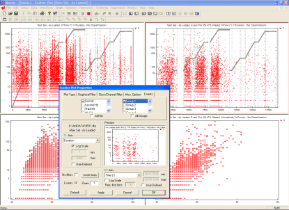
Previous Page | Noesis Main Page | Next Page

Noesis Source Location

The plot-properties dialog refers to the upper-right graph and the user has chosen to view the first hits of zonal group 2 only.
 
Noesis typical screen with zonal location information applied to an actual acoustic emission data file (PAC DTA format). The plot-properties dialog refers to the upper-right graph and the user has chosen to view the first hits of zonal group 2 only. The difference with the upper left graph where all hits are shown is evident. 
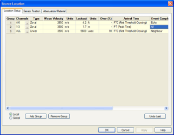
The location set-up menu is easier than ever!
 
The acoustic emission zonal location set-up dialog. Simple selections allow the user to add, delete and modify each location group in seconds.
Various units (both SI and Imperial) are supported for international users.

Noesis implements a Zonal Location mode (LOC module required). Location information is available only if the data file(s) loaded are PAC DTA, TDA or WFS Acoustic Emission data files. The user can use the Location Setup Dialog (see picture above) to quickly set-up location groups and their properties. Some of the features available in the zonal location module are listed below:

  • Two location algorithms are available: Zonal and 3D Linear.

  • Extraction of location information in the form of Event Sequence (1st, 2nd, 3rd, ... hit) and Event Correspondence (which event each hit belongs to). This improves on typical Zonal Location in acoustic emission as more information than simply the First Hit is available to the user.

  • 3D Linear location uses the above information to locate the source between the sensors providing the x-y-z coordinates of the source. The location algorithm can also function in 2D as an X-Y Linear location and in 1D as a normal Linear location.

  • Simple to understand and use interface (set-up) dialog.

  • Automatic unit conversions in SI and Imperial systems. The user can enter any units convenient and Noesis will automatically perform the conversion.

  • Zonal and Linear Location information is fully implemented in the graphs so that the user can choose to view data (graphical filter) according to their Event Sequence (see above) and Group. Data can be selected with the mouse even from x-y-z plots so that their nature can be further investigated.

  • Maximum number of Sensor Groups is 32 allowing the user to include complex geometry test data in a proper Zonal Location analysis..

  • All parameters can be set by the user, even the method used to define subsequent hits to an event.